Ā Kawatiri urutau i ngā āhuarangi
Responding to a changing climate in Westport
Responding to a changing climate in Westport
In late 2025 the Commission met with people in Westport to hear how climate change and severe weather is affecting their community, and how they are responding to it.
Driving up the rugged coastal road, we had a firsthand view of the dramatic landscape that has brought settlers and visitors to the area for centuries. Mana whenua, Ngāti Waewae, welcomed our small group at Arahura Marae.
Over the following days we would meet with groups from across Westport and its surrounding areas: farmers, businesses, local residents, regional and district councils, community organisations and conservation staff.
This case study sets out what we saw and heard on our trip: the challenges, the responses, and what would most help as the town moves into the future.
Read more about the Commission and why we do case studies.
Tihei mauri ora!
Me wehi ki te Kaihanga
Ki a rātou kua tahuri atu, haere, haere, haere atu rā
Ka mihia a Ngāti Waewae, koutou ko te hapori, ko ngā kaipakihi o Kawatiri
Nō mātou te maringanui kia kite ā kanohi, ā, kia wānanga tātou mō ngā huringa āhuarangi me ā koutou nā urutaunga, auaha hoki.
He maha kē ngā taumata ka pikihia e koutou, ngā waipuke nanakia mai, tētahi hapori tūhāhā mai, rīanga kore mai.
Ahakoa tērā, he mārohirohi koutou, ka kimihia te pae tawhiti kia mau, kia ū, me tō koutou nei tōmina, ka tautokohia tēnā e ngā kaupapahere ā motu.
Ko koutou tērā me te whakaaro, me mate ururoa, kaua ko te mate wheke.
Ka manakohia mai, kua pupuritia tika ā koutou nā kōrero kei roto i te tuhinga nei hei taonga mā koutou, mā te motu hoki.
E kore e ārikarika te mihi, tēnā koutou, tēnā koutou, tēnā koutou katoa.
From the Chief Executive
Our visit to Westport in September 2025 gave us the chance to see first-hand how a changing climate is shaping life on the West Coast.
As a small and geographically isolated town, Westport is used to tackling challenges head-on. That determination has only strengthened in the wake of the devastating floods of July 2021 and February 2022.
Since then, the town has been actively exploring options for a more resilient future, while making good progress with flood protection measures. But the challenges don’t stop with the immediate aftermath of major events.
Thank you to the dozens of people in Westport who welcomed us into your homes and businesses and shared your stories with us.
Jo Hendy, Chief Executive
the importance of being on the ground
Case studies are a valuable part of the Commission’s mahi. Hearing directly from people on the ground is particularly important for studying climate change adaptation.
The ways that climate change affects people and communities varies from region to region, just as regions vary in their capacity to respond.
This is our fourth adaptation case study. In 2024, our case studies of Wairoa and South Dunedin formed part of our first assessment of progress made on the Government’s national adaptation plan. In late 2025, we published a case study on Te Taitokerau/Northland region.
Insights from our case studies fed into two key adaptation reports in 2026:
- The national climate change risk assessment.
This assessed a wide range of risks to the country from climate change and identified the most significant climate risks for the Government to respond to in the next six years. - A report on progress made under the national adaptation plan.
This reviews government action and recommends what will be needed in the next national adaptation plan.

Commission staff review Master Planning material at the EPIC Kawatiri Westport co-working space. Photo / He Pou a Rangi Climate Change Commission
Commission staff review Master Planning material at the EPIC Kawatiri Westport co-working space. Photo / He Pou a Rangi Climate Change Commission
About Westport
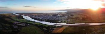
The town at the mouth of the Buller River
The Buller River flows from Lake Rotoiti in Tasman District down through the Buller Gorge and into the Tasman Sea. Its Māori name is Kawatiri, which means deep and swift. This name is fitting: when in flood, it has the highest recorded flows of any river in Aotearoa New Zealand.
The Buller isn’t the only river in Westport; snaking around the northeast side of town is the smaller Orowaiti River, just 15 km long. To the northwest is the Tasman Sea, meaning Westport is effectively surrounded by bodies of water on all sides.
The notoriously wet West Coast
As well as water on three sides, Westport often receives it from above: the West Coast has by far the highest annual rainfall of any region in the country.
The distinct West Coast climate, combined with the town’s proximity to multiple bodies of water, leaves it prone to coastal, river and surface flooding. Significant floods have occurred throughout the town’s history.
However, the emerging pattern is one of heavier rainfall, more frequently, and climate projections show this is only set to continue.
The people we met spoke frankly and passionately about their lives in Westport: how the wild weather is a way of life that they are used to contending with, but an increasingly disruptive one.
The Buller River as it passes through Buller Gorge. Photo / AG Images
The Buller River as it passes through Buller Gorge. Photo / AG Images
Māori in Te Tai Poutini
When Māori arrived in Aotearoa New Zealand in the late 13th century, they soon reached Te Tai Poutini, the West Coast. Those early settlers are thought to have been Waitaha people, the first settlers of Te Wai Pounamu, the South Island.
It’s likely that their early settlements were around the Māwheranui (Grey) and Hokitika rivers – key areas for pounamu-gathering. By the 16th or 17th centuries Ngāti Wairangi occupied Te Tai Poutini, and this continued until Ngāi Tahu people from Waitaha Canterbury arrived in the 18th century.
Today, the hapū who hold mana whenua in Te Tai Poutini are Ngāti Waewae and Ngāti Mahaki, collectively known as Poutini Ngāi Tahu. Ngāti Waewae, mana whenua of the Buller region, possess rich whakapapa to the earlier inhabitants, specifically Waitaha, Ngāti Māmoe, and Ngāti Wairangi.
The region provided vital resources that sustained the hapū for generations. Kawatiri (Buller) River was historically used for transport and as a rich source of food with many mahinga kai (food gathering) sites across the region. The area remains a spiritual and practical focal point for the hapū.
A duo of devastating floods
In July 2021, Westport and its surrounding areas experienced heavy rainfall that led to flooding across much of the town.
Seven months later, in February 2022, when many houses in Westport were still awaiting repairs from damage caused by the 2021 flood, a second serious rain event occurred in the Buller District.
This time the flooding was spread more widely, affecting many rural communities. This meant fewer evacuations and red- or yellow-stickered residential properties in the township, but greater damage to infrastructure than the July 2021 floods.
By the numbers: the July 2021 flood
- 2,000 residents evacuated.
- $73.1 million in insurance claims in Westport spanning house, contents, and motor vehicle policies.
- $24.1 million in insurance claims in areas outside of Westport.
- $17.08 million for a temporary accommodation village for flood-affected impacted Westport residents.
- Approximately $2 million spent by KiwiRail on rail line asset repairs in the Buller area.
- 1,400 lost cattle.
Increasingly frequent and severe weather events
“Westport always gets its two metres of rainfall a year, but what I’m seeing in the last five or six years is long dry spells followed by a deluge.”
While heavy rainfall that causes flooding is not new to Westport, climate change is increasing the severity and the frequency of such events.
These increases are intensifying and will continue to. Some Westport residents are noticing this already, telling us that the total annual rainfall doesn’t seem to have changed, rather that now sometimes “it all comes at once.”
The changing climate
Aotearoa New Zealand is already experiencing the impacts of climate change and these impacts will only intensify in the future. This is backed up by modelling that estimates that the July 2021 Westport event was made 10% worse by climate change. In Aotearoa New Zealand, climate change intensifies heavy rainfall in two main ways:
- Our planet is warming, and warmer air holds more water – about 7% more for every degree of warming. When this water is released, the precipitation that results can be 10% to 20% heavier than it would otherwise be.
- Warmer ocean temperatures and more moisture in the air can increase the severity of tropical cyclones.
- Warming ocean and air temperatures mean the area in which cyclones develop has been widening (and, in the southern hemisphere, moving closer to Aotearoa New Zealand).
As well, Buller District is highly exposed to coastal flooding, and sea levels around Aotearoa New Zealand are projected to rise by about 0.2 m by 2050 and up to 0.6 m by 2090, with higher rises possible.
What climate projections look like for Westport
Climate change projections show different possible scenarios over the coming decades, which can help inform decision-making around adapting to climate change.
Using 2005 as a base year, projections show the Buller District could see the following climate changes throughout the rest of the century.
- Annual rainfall overall is projected to change. Average rainfall increases in a low climate impact scenario over the 2005 baseline by 2090. In a high climate impact scenario, the models give varying results for changes in annual and seasonal rainfall by 2050 and 2090. (See page 23 in the full case study for the range of projected changes).
- The intensity of rainfall is projected to increase. Extreme rainfall events refer to how much rainfall there is on the wettest 1% of days in a year (roughly the three wettest days in each calendar year). In short: will likely be even wetter.
- Mean temperature changes are projected to increase in line with the rest of the country.
- Hot days are projected to increase. Hot days refer to days where the temperature is above 25°C. In the base period (1995–2014), there were on average 4 hot days per year.
To read more about climate projections for Westport, read the full case study.
What we heard on the ground
The local economy
The West Coast is a natural environment of immense value, featuring rainforests, glaciers, rivers and gorges, as well as geological features such as the Pancake Rocks and blowholes at Punakaiki. The region also has ancient native trees, unique wildlife, and high biodiversity.
Agriculture, mining and tourism are the biggest contributors to the local economy, and all three are inextricably linked to the West Coast’s natural environment.
Farmland next to the Buller River as it heads towards Westport. Photo / AG Images
Farmland next to the Buller River as it heads towards Westport. Photo / AG Images
Agriculture
The agriculture sector is the largest and fastest-growing industry in the Buller District. The farmers we spoke to shared their passion for their land and their livestock, as well as the devastating effects that severe weather events had on their farms.
They were unequivocal that the biggest challenge for them is not the flooding itself, but the days and weeks following an event. This is when farmers must continue to run their farm while also undertaking major clean-up and repairs – often without their full staff.
“You can’t do anything on a farm without roads – all our fuel, feed and fertiliser travels on the roading network, as well as the tankers that collect our milk.”
We heard time and again how critical road connections are for farmers. They said that clearing blocked roads and repairing damage to infrastructure was essential in order to minimise disruption to business.
“It’s unusual for the West Coast, but we do have to think about a lack of water in the future, think about our future irrigation, and being as efficient as possible with the water we do have.”
Dairy farmer Stu Bland on the Blands’ farm near Reefton, West Coast. Photo / AG Images
Dairy farmer Stu Bland on the Blands’ farm near Reefton, West Coast. Photo / AG Images
“It’s not so much the flood itself; that comes and goes. It’s ten or twenty days after when you have to carry on running your farm while making repairs. It’s really about how you cope in the aftermath, and the support you have.”
Carol Keoghan (left) and Rebecca Walker, on Rebecca’s farm on the outskirts of Westport. Carol and Rebecca are both members of the Rural Support Trust. Photo / AG Images
Carol Keoghan (left) and Rebecca Walker, on Rebecca’s farm on the outskirts of Westport. Carol and Rebecca are both members of the Rural Support Trust. Photo / AG Images
By the numbers: Westport’s agriculture sector
- 17.9%: agriculture, forestry and fishing’s share of total industry in the Buller District.
- 5.2%: agriculture, forestry and fishing industry’s growth between 2024 and 2025 (valued at $7.2 million)
- 8.9%: growth of dairy herd area between 2024 and 2025.
Mining
Westport was founded during the gold rush of the 1860s, and mining continues to have a strong presence in the community.
We heard how the industry is a bedrock of the local economy, employing hundreds of fulltime staff and being a major contributor to the region’s GDP.*
We also heard how heavy rainfall can disrupt mine operations, and surface flooding and landslides cause road and rail line closures that disrupt the export of coal.
* While coal mining has had, and continues to have a major influence on the West Coast economy, the Commission’s advice is for a rapid phase-out of coal in electricity generation and industrial process heat to meet New Zealand's 2050 net zero target and to contribute to the global goal of limiting warming to 1.5°C.
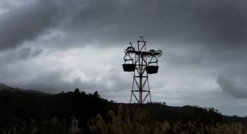
“Water management drives the entire mine management process”
Residents told us how the sector supports the community with time, money and expertise: many mining staff have advanced first-aid and civil defence training, which is valuable during severe weather events. Established mining companies in the region have made financial contributions that support resilience, such as purchasing communications infrastructure to assist communities when they are cut off.
Many people also spoke frankly to us about coal mining being a sunset industry, although the region’s long-term plan is to transition away from traditional extraction opportunities towards other natural resources.
“While the market is currently subdued due to geopolitical issues, generally demand is through the roof for ilmenite, which goes into titanium, you use garnet for high-precision cutting, and monazite and zircon in other technologies.”
By the numbers: Westport’s mining sector
- 16.6% mining’s share of total industry in the Buller District.
- 400 fulltime employees at the Stockton Mine in 2025.
- $36 million in wages paid by Bathurst Resources in 2026.
- $752,000 contributed to projects by Bathurst Resources Ltd via the Buller Resilience Trust.
Pictured (from left) Stockton Mine employees Bernie Wesselingh, Tom Lucas and Charles Bruning, in the Buller Civil Defence Emergency Operations Centre in Westport. Photo / AG Images
Pictured (from left) Stockton Mine employees Bernie Wesselingh, Tom Lucas and Charles Bruning, in the Buller Civil Defence Emergency Operations Centre in Westport. Photo / AG Images
Conservation and tourism
The West Coast landscape – rugged, lush and untouched, with high biodiversity and unique native fauna – has long been a drawcard for visitors to the region.
87% of the Buller District is conservation land, under Department of Conservation (DOC) jurisdiction. As well as protecting the land, DOC has a mandate to host visitors to the region, including at the popular Paparoa and Heaphy Great Walks.
DOC staff said they are challenged doubly by severe weather – infrastructure damage increases their workload, while the weather itself reduces the time available to do the repairs.
“Just getting the work done is difficult. We need to get it all done in the fine periods.”
As well as responding to damage cause by climate events, the trend towards warmer weather – especially the milder winters – is impacting biodiversity on DOC land: pest and predator populations are increasing, and weeds are spreading faster. At the same time, many rare and treasured native species are finding the changes in weather patterns increasingly challenging.
DOC is planning how to adapt in the future. At a national level, this means determining exposure to climate hazards, assessing risks for various infrastructure, species and ecosystems, and then planning and carrying out work to reduce those risks. At a local level, this means investing time and money to plan how they build tracks and positions culverts to ensure long-term resilience.
Jane Williams, Programme Lead (Bathurst Project) at the Department of Conservation, in native bush near Westport. Photo / AG Images
Jane Williams, Programme Lead (Bathurst Project) at the Department of Conservation, in native bush near Westport. Photo / AG Images
By the numbers: Westport’s tourism sector
- $94.3 million total tourism spend in Buller District in 2025.
- 3.6% increase in tourism spending in Buller District between 2024 and 2025. Spending across New Zealand was consistent with the year before.
- 500,000 visitors each year to Dolomite Point at Punakaiki (before the impact of COVID-19).
- 2 of the Department of Conservation’s 11 Great Walks are in Buller District.
“It’s more expensive, but we need to be resilient. We’re putting effort in upfront with the design and construction and it pays off.”
Westport is often cut off in severe weather
The West Coast has limited connections to the rest of the South Island and the road and rail networks between them are regularly affected by severe weather – most often from landslides or fallen trees.
These routes are critical for connecting people to essential services and surrounding communities, and for export and import. The majority of the region’s food comes from outside the West Coast, and the mining and agriculture industries both require road and rail access to transport their products.
People said roading access is critical for providing timely assistance after a severe weather event – for repairs to houses and larger infrastructure such as power lines and stormwater drains.
Who gets hit hardest by climate change?
“People are bogged down in the day-to-day here; they can’t comprehend restarting somewhere else. We can see people don’t have options here – they are living very basically, they have no money to think about a new place to live.”
A complex web of factors affect how hard certain people and communities are hit by the effects of climate change, and how equipped they are to respond to those effects.
These factors can be socio-economic, cultural, and historical. Around 41% of the Westport population lives in areas of ‘high socioeconomic deprivation’ – more than double the national average.
Indicators like this help us understand whether people are likely to have enough money to cope with crises and losses caused by climate hazards, and whether they are in a position to consider pre-emptive action, like moving house.
Investing in resilience
In June 2023 the Government committed $22.9 million to the Resilient Westport package to support initiatives to improve flood resilience.
The package includes amending the building code for floor levels, emergency management planning and implementation, and improving stormwater infrastructure.
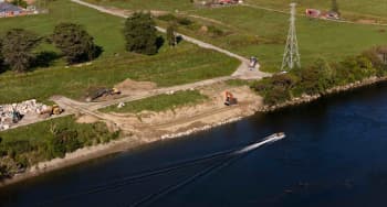
The largest piece of work is a 16 km-long network of permanent stopbanks and floodwalls, and portable barriers to defend the town from the Buller and Orowaiti rivers. Most of the structures will be around 2 m high, with some up to 3.6 m.
“Walls are a valid de-risking mitigation, but they’re not everything.”
While many we spoke to felt positive about the stopbanks, we also heard that there are areas of the town that would be outside of the protected area. And residual risk will remain: the measures are designed for a 1-in-100-year flooding event, which is expected to occur more frequently with climate change.
A vision for the future
One high-profile part of the package is the Master Planning process: an iterative, design-based planning process that looked at short-, medium- and long-term options for Westport residents.
This process ultimately ended with a vision of Westport residents moving to an area of land currently owned by Landcorp (operating as Pāmu Farms) at Cape Foulwind, southwest of the current township. The goal is for a long-term, multi-generational phased move from the current location, rather than a single relocation.
The Master Planing project is now in its third and final stage, looking at spatial planning, land access and financial implications, including negotiating with central government, banks, and insurers.
Pāmu land at Cape Foulwind, the proposed site for a new Westport township. Photo / AG Images
Pāmu land at Cape Foulwind, the proposed site for a new Westport township. Photo / AG Images
What people need to support adaptation
“There is lots of funding to do a plan, but nothing left to execute with. That’s why 75% of plans just sit on the bookshelf.”
Throughout our visit, people were not shy about telling us what they need to continue to adapt.
Staff at regional and District councils told us that national policy direction needs to be driven by longer-term thinking and planning.
We heard a strong view that adaptation work should be locally led, but with a clear and consistent mandate from central Government to help drive action forward.
Above all, we consistently heard calls for increased funding to allow councils to implement work after the research and planning phases are complete.
Some farmers told us that what they considered ‘chopping and changing’ of regulations makes it hard for them to get things done, including preparing for and responding to extreme events. They told us that clear guidelines around what they can do for themselves before and immediately following an event would enable them to get their land and business up and running again as efficiently as possible.
Read more about adaptation in Aotearoa New Zealand
The stories we heard in Westport contributed to our work on the second national climate change risk assessment, and in our monitoring of progress under the Government’s national adaptation plan.
There are important distinctions between case studies based on people’s lived experience, and the assessment of long-term climate risks and central government action that form the basis of those reports. Case studies provide a close view: what is happening in one area, at this time.
The longer view – that the country can use to assess what action is needed now to prepare for the future – is the focus of our statutory 2026 reports.
Published: May 2026
© Crown Copyright
This work is licensed under the Creative Commons Attribution (CC-BY-NC-ND) licence. The work can be downloaded, copied or distributed in any medium or format in unadapted form only, for non-commercial purposes only, and only if attributed to the Climate Change Commission.
To view a copy of this licence, visit https://creativecommons.org/licenses/by-nc-nd/4.0
For images that include people: Out of respect for the people photographed, we ask that these images only be used in the context of this case study.
Disclosure statement: As anticipated by the appointment criteria, the Climate Change Commissioners come from varying fields such as adaptation, agriculture, economics, te ao Māori and the Māori–Crown relationship. While a number of board members continue to hold roles within these fields, our advice is independent and evidence-based. The Commission operates under its Interests Policy, which is derived from the Crown Entities Act 2004. You can read more about our board members on the Climate Change Commission website. The Commission regularly updates and publishes on its website a register of relevant board interests.
 Built with Shorthand